
To achieve the transatlantic scale and incorporate the diversity of sensitive Atlantic deep-water ecosystems, ATLAS has assembled 12 Case Studies that follow the major Atlantic current patterns. These were selected on basis of
- proximity to Blue Growth activities
- presence of focal ecosystems
- availability of existing data/samples
- and opportunities for offshore cruises during the ATLAS project
Research cruises for ATLAS are available from national contributions with additional ship time provided by our North American partners and industry associate partners. ATLAS Case Studies lie along critical paths of the Atlantic meridional overturning circulation (AMOC) with some currently classified as Vulnerable Marine Ecosystems, Ecologically or Biologically Significant Marine Areas or in areas that have been proposed as such. Case Studies cross-cut the project and give the biogeographic, regulatory and jurisdictional range needed to meet ATLAS’s objectives.
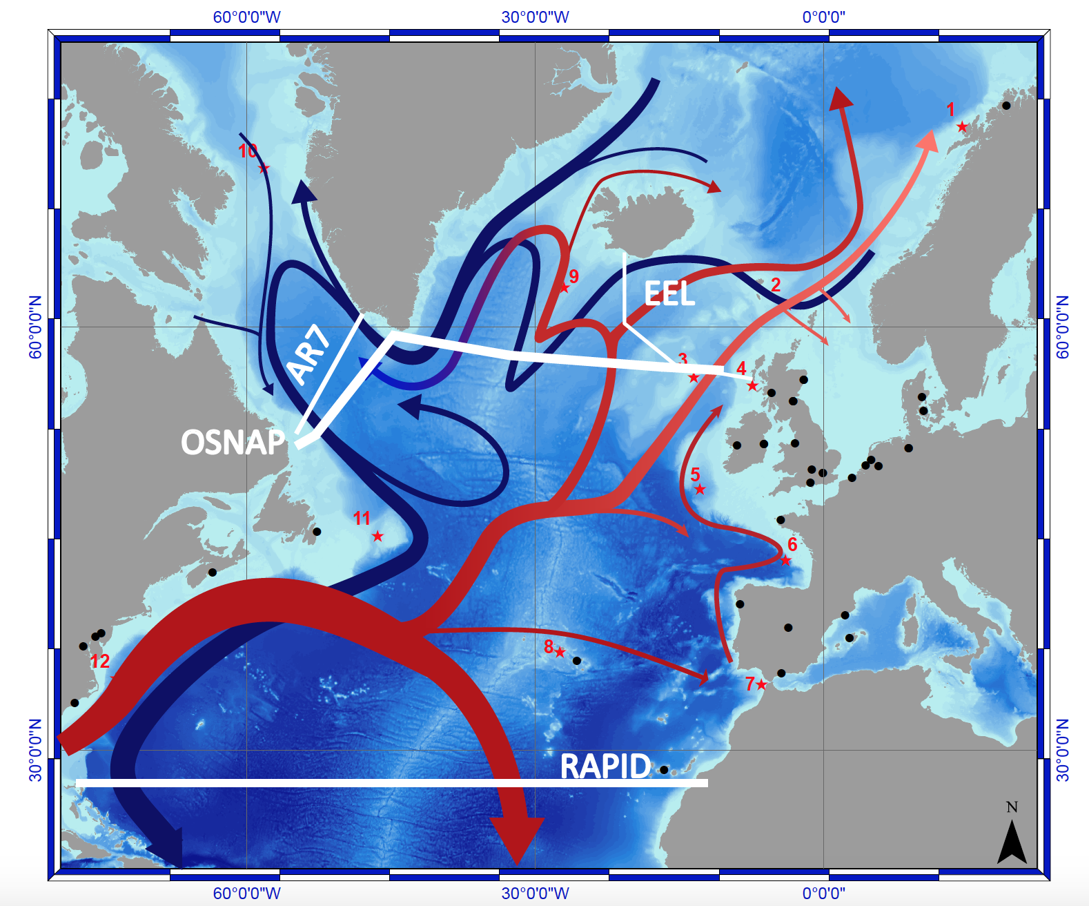
The AMOC consists of warm water (red arrows) flowing north and cold water returning southward at depth (blue). AMOC arrays are shown at 26.5°N (RAPID) and in the subpolar North Atlantic (OSNAP) with the UK Extended Ellet Line (EEL) and Canadian (AR7) hydrographic sections indicated. Black dots represent the ATLAS partner locations and Red stars represent the ATLAS Case Studies.
Click on the links below to find out more about each case study.

In collaboration with the Institute for Marine Research, Statoil has operated a cabled ocean observatory outside Lofoten-Vesterålen in northern Norway since 2013. Due to the narrow continental shelf, the area is described as the gateway to the Barents Sea. The marine ecosystem is highly valuable and productive; and an important habitat and spawning ground for a number of key species in northern ecosystems. Particular focus is on the Northeast Atlantic cod and cold-water corals including Lophelia pertusa which forms substantial framework reefs in this area. Other important species include herring, sponges and soft corals. Fisheries and, closer to shore, tourism are important sectors in the region. The area is not open for oil and gas activities; however, this is currently under discussion.
. © Joint Nature Conservation Committee (2012).")
This case study targets the Faroe Shetland Channel. It will focus on the dynamics, connectedness, sensitivity, and spatial management of resources provided by the deep-sea sponge ecosystems. The physical barrier of the Wyville Thomson Ridge is a large obstacle for southward flowing cool Nordic waters, leading to significantly different benthic communities downstream of deep water flow. Large protists, sponges, corals, and surface-dwelling acorn worms are just some of the fauna forming distinctive habitats that are known to support diverse communities of associated species in the region. Stalked sponges occupy deep-water sandy sediments, brittlestar beds are found on gravel, sponges and soft corals colonise mixed gravel-cobble-boulder bottoms, and well-developed communities inhabit coarse sediments built up into the furrows and ridges created by grounded icebergs. A diverse range of benthic ecosystems occurs in the channel, including cold-water coral reefs, deep-sea sponge aggregations and offshore deep-sea muds. Diverse epifaunal assemblages of sponges, corals, crinoids and dense beds of ophiuroids also occur.
 on Lophelia pertusa cold-water coral reef framework (Logachev coral carbonate mounds, Rockall Bank, North-East Atlantic). © Changing Oceans Expedition (2012).")
Enhanced hydrographic mixing, upwelling and down-welling around the Rockall bank may give rise to highly localised and specialised biological communities such as sponge aggregations, Lophelia reefs and coral gardens. Lophelia pertusa occurs on Rockall Bank principally at depths between 200-400 m, but also in certain areas deeper than 500 m on the slopes of the bank. Gorgonians and black corals are found on the bank and down the slopes. Sea-pens are recorded from the bank and especially the sedimentary slope areas. Sponges have been recorded across the bank, most notably from the western slope. There is evidence of an active cold-seep ecosystem in the area on the western margin of Rockall Bank at a depth of 1200 m. It is therefore a highly diverse and unique ecosystem which is why it has been proposed to become an ‘Ecologically and Biologically Significant Area' (EBSA) under the Convention on Biological Diversity.
, anthozoans (Parazoanthus anguicomus) and brittle stars (ophiuroids) (Mingulay Reef Complex, North-East Atlantic). © Changing Oceans Expedition (2012).")
Unlike most cold-water coral reefs, the Mingulay Reef Complex is a rare example of an inshore ecosystem at100-200 m of water depth, located 14 km east of the island of Mingulay in the Sea of the Hebrides, western Scotland. Distinctive coral mounds up to 5 m high are formed by the stony coral Lophelia pertusa, mounds which have been growing periodically over the last 7,000 years. The accessibility and density of environmental data from Mingulay have made it an ideal site for studies examining the vulnerability of cold-water corals to ocean warming and acidification since 2003. Samples of Lophelia pertusa from Mingulay have been used in experimental studies that demonstrated the hidden impacts of acidification on coral biomineralisation, growth and skeletal strength.
The Porcupine Seabight (PSB), off the west coast of Ireland, is an area that has been intensely researched for decades. Notwithstanding historical research presence in the area, the importance of PSB cold-water corals only came to prominence at the beginning of this century. Indeed the Belgica Mound province was one of four areas designated by the Irish authorities as a candidate Special Area of Conservation (SAC) under the European Union’s Habitats Directive in 2006 – the first offshore SACs in the EU. In recent times, there has been an increase in interest in oil and gas exploration in the PSB. The coverage of oil and gas exploration concessions in the most recent Atlantic Margin licensing round in 2015. Given the presence of several other stakeholders in the PSB associated with fishing, cable and telecommunications, scientific research and conservation, the PSB is an ideal candidate to develop maritime spatial planning approaches within ATLAS.
 on a vertical wall (Bay of Biscay). © Ifremer, BobEco Expedition (2011).")
The continental margin of the northern Bay of Biscay is divided into the Celtic and Armorican margins, which are both characterised by a relatively broad continental shelf and a steep, canyon-dominated, slope. Historical data on the occurrences of frame-building scleractinian cold-water corals, antipatharians, gorgonians and large sponges in the Bay of Biscay has mainly come from fisheries surveys. More recent studies confirmed the occurrence of cold-water coral habitats, at the boundary between the Eastern North Atlantic Central Water (ENACW) and the Mediterranean Outflow Water (MOW). The distribution of Lophelia pertusa and Madrepora oculata is skewed towards the northern half of the Bay. The two reef-building species co-occur in reefs of the Bay of Biscay but show different genetic and historical patterns in the Northeast Atlantic. Populations of L. pertusa are genetically homogeneous from Iceland to the Mediterranean Sea while populations of M. oculata from Iceland, Ireland, the Bay of Biscay and the Mediterranean Sea are genetically distinct. The exploration of the canyons in the Bay of Biscay was guided by historical data, dating back to the 19th to mid-20th centuries. In many cases, historical records of L. pertusa and M. oculata reefs turned out to be coral rubbles on the upper slope and interfluves of canyons, while living corals were mainly found along the flanks of the canyons.
 and one black coral specimen (Bathypathes sp.) © Instituto Español de Oceanografia (IEO) edwaves Expedition (2016)")
The understanding of the North Atlantic ecosystems dynamics, connectivity and biodiversity requires an integrated knowledge of its present and past connection with the Mediterranean Sea. Many deep-sea species, including structural engineers such as cold-water corals and a wide variety of gorgonians and sponges, as well as several species of fish and other invertebrates are distributed in both the Atlantic and the Mediterranean basins. Indeed, it seems that some species (e.g. L. pertusa) recolonised the Atlantic from the Mediterranean after the last glacial episodes.
 on rocky bottoms (Azores). © DEEPFUN")
The Azores is a volcanic archipelago located in the northeast Atlantic, lying above a tectonically active triple junction between the North American, Eurasian and African plates. Oceanography in the region is influenced by two eastward currents branching from the Gulf Stream, the North Atlantic Current in the north and the Azores Current to the south. Mediterranean water eddies are also an important feature in the region, present as distinct lenses of warm and salty Mediterranean water at 800-1200 m deep. The water current patterns result in a complex circulation, with high salinity and temperature and a low nutrient regime, except for some localised upwelling associated with island slopes and seamounts.

Mid-ocean ridges are among the largest continuous marine habitats known, with an area comparable to or larger to the relatively well-studied continental shelf and slope habitats. Ridge community ecology and biodiversity are relatively poorly understood, with the exception of chemosynthetic ecosystems such as hydrothermal vents. Our understanding of the effects of ridges on the composition and distribution of pelagic and benthic fauna, including commercially important taxa, is limited. Ridge communities are of considerable scientific and commercial interest as they may express endemism (e.g. hydrothermal vent communities) and may also significantly influence the processes affecting the slope and shelf biota such as intercontinental migration and dispersion.
, sea anemones (actinians) and sponges. © Fisheries and Oceans Canada (DFO).")
The Davis Strait joins two oceanic basins, Baffin Bay and the Labrador Sea, and separates western Greenland and Baffin Island. It connects to the Arctic Ocean in the north via the Baffin Bay and to the Atlantic Ocean in the south via the Labrador Sea. It is considered to be the world’s largest strait and is renowned for exceptionally strong tides, ranging from 9 to 18 m, and complex hydrography. The shelves extending from both Canada and Greenland typically range between 20 and 100 m in depth and are traversed by deep troughs. At its narrowest point, a ridge or sill up to approximately 600 m depth extends between Greenland (at Holsteinborg, Sisimiut) and Baffin Island (at Cape Dyer). The slopes along the Labrador Sea flank of this ridge and farther south along the Labrador and West Greenland shelves drop to 2500 m or more. On these slopes coral and sponge have been found, including the only known Lophelia pertusa reef in Greenlandic waters. South of Davis Strait the waters off west Greenland support intense phytoplankton blooms in April, which progress northward into the Baffin Bay in May as the seasonal ice-cover retreats. These blooms are characterised by high phytoplankton biomass and a community of grazers dominated by large copepods, i.e. Calanus. Within the study region Calanus provide an important food source for higher trophic levels (e.g. fish, seabirds, whales). In addition, however, they play a key ecological role in supplying the benthic communities with high-quality food via the production of large and fast-sinking faecal pellets. The Baffin Bay and the Davis Strait have the only large-scale commercial fisheries in Canada’s Arctic.
The Flemish Cap is an Oceanic Bank located in an Area Beyond National Jurisdiction within the Northwest Atlantic Fisheries Organisation Regulatory Area (NAFO) and separated from the Grand Banks by the Flemish Pass. It is situated in a transition area between the cold-waters of the Labrador Current and warmer waters influenced by the Gulf Stream. It is mainly covered with soft sediments and there are stones scattered in the entire area. The main focal ecosystems are sponge grounds and cold-water corals.
 and squat lobster (Eumunida picta). Baltimore Canyon 2012 © Steve Ross")
The western North Atlantic Ocean between Cape Hatteras and Cape Cod (USA, Middle Atlantic Bight, MAB) is characterised by numerous and diverse submarine canyons that straddle the outer shelf and slope. Research interests in these canyons and associated ecosystems have increased in the last 20 years, largely in response to potential energy exploration and development. This ATLAS case study focuses on the area between Baltimore Canyon and Cape Hatteras, but also draws on relevant data from recent studies on the Blake Plateau off the southeastern US. This area represents a unique transition from the rocky and carbonate bottom Blake Plateau that is oceanographically dominated by the Gulf Stream to the softer sediment, canyon dominated area north of Cape Hatteras, influenced by colder currents.